Tue June 9-12 Alley Storm
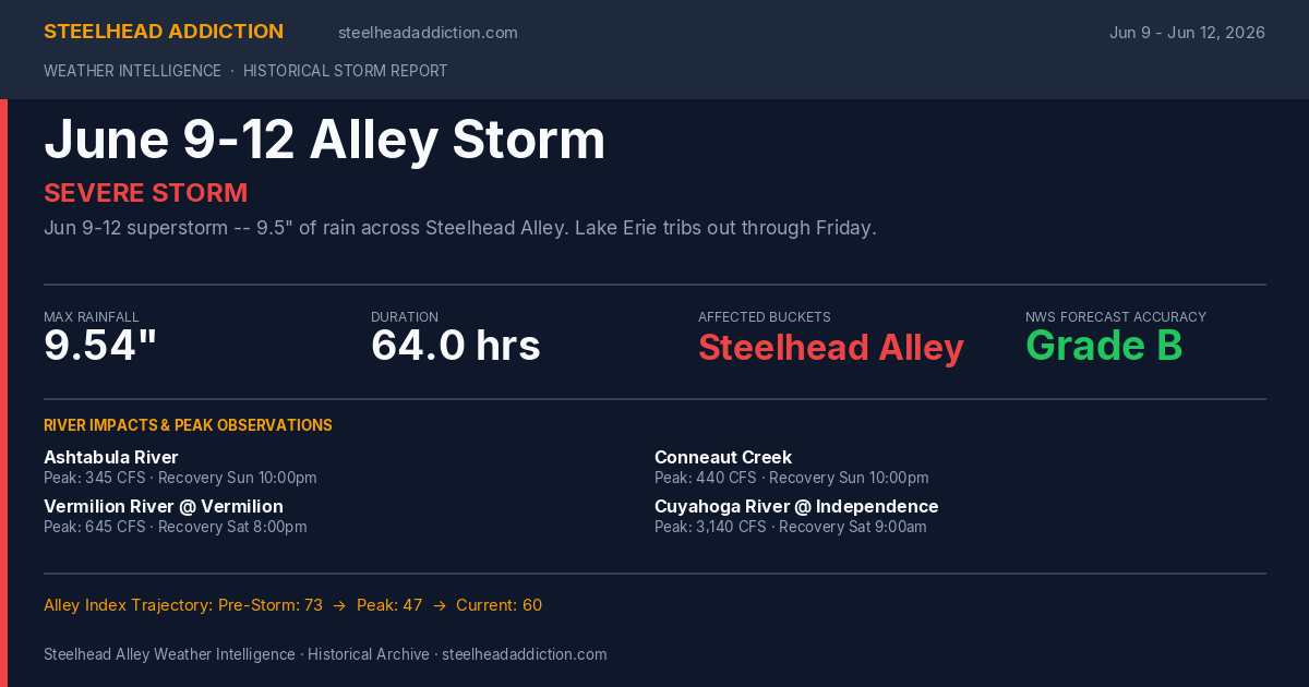
Jun 9-12 superstorm -- 9.5" of rain across Steelhead Alley. Lake Erie tribs out through Friday.
Meteorological Analysis
A severe storm system rolled through the Steelhead Alley region starting on Tuesday, June 9, 2026 and lasting until Friday, June 12, 2026. The storm was active for approximately 64 hours, dumping a maximum of 9.54" of rain across affected zones. Geographically, the weather system impacted the New York (Lake Erie), New York (Lake Ontario), Ohio, Pennsylvania regions, causing rapid water-level rises on multiple tributaries.
Gauges recorded significant river responses, particularly along Ashtabula River (peaking at 345 CFS), Conneaut Creek (peaking at 440 CFS), Vermilion River @ Vermilion (peaking at 645 CFS), Cuyahoga River @ Independence (peaking at 3,140 CFS), Brandy Run near Girard (peaking at 6 CFS), Elk Creek (peaking at 743 CFS), Walnut Creek (peaking at 315 CFS), Twenty Mile Creek (peaking at 479 CFS), Crooked Creek (peaking at 126 CFS), Cattaraugus Creek (peaking at 637 CFS), Chautauqua Creek (peaking at 52 CFS), Eighteen Mile Creek (peaking at 54 CFS), Huron River (peaking at 416 CFS), Black River (peaking at 421 CFS), Euclid Creek (peaking at 129 CFS), Canadaway Creek (peaking at 381 CFS), Silver Creek (peaking at 72 CFS), Buffalo Creek (peaking at 96 CFS), Cazenovia Creek (peaking at 261 CFS), Salmon River (peaking at 299 CFS), Oak Orchard Creek (peaking at 1,400 CFS), Genesee River (peaking at 1,870 CFS), Sandy Creek (Hamlin) (peaking at 82 CFS), Irondequoit Creek (peaking at 293 CFS), Johnson Creek (peaking at 206 CFS), Eighteenmile Creek (Niagara) (peaking at 63 CFS), Black River (Watertown) (peaking at 2,540 CFS), Sandy Creek (Adams) (peaking at 85 CFS). Angling conditions deteriorated quickly during the peak flow periods, leading to temporary washouts. Gaging stations monitored the recovery times as flows began returning to their baselines, mapping out the best windows for fishermen to get back on the water.
From a weather prediction standpoint, the NWS forecasts for this event received an aggregate score card grade of 'B'. Gaging observations were matched against NWS precipitation models to assess the forecasting margins, highlighting the variance in local rainfall amounts across the lake shores.
Tributary Response & Recovery
Ashtabula River
- Pre-Storm Flow
- 32 CFS
- Observed Peak
- 345 CFS
- Peak Time
- Jun 12, 01:00
- Recovers By
- Jun 14, 22:00
Conneaut Creek
- Pre-Storm Flow
- 39 CFS
- Observed Peak
- 440 CFS
- Peak Time
- Jun 11, 23:00
- Recovers By
- Jun 14, 22:00
Vermilion River @ Vermilion
- Pre-Storm Flow
- 68 CFS
- Observed Peak
- 645 CFS
- Peak Time
- Jun 11, 06:00
- Recovers By
- Jun 13, 20:00
- Baseline Return
- Jun 13, 16:00
Cuyahoga River @ Independence
- Pre-Storm Flow
- 342 CFS
- Observed Peak
- 3,140 CFS
- Peak Time
- Jun 11, 12:00
- Recovers By
- Jun 13, 09:00
- Baseline Return
- Jun 13, 05:00
Brandy Run near Girard
- Pre-Storm Flow
- 3 CFS
- Observed Peak
- 6 CFS
- Peak Time
- Jun 11, 18:00
- Recovers By
- Jun 11, 23:00
- Baseline Return
- Jun 11, 19:00
Elk Creek
- Pre-Storm Flow
- 8 CFS
- Observed Peak
- 743 CFS
- Peak Time
- Jun 15, 00:00
- Recovers By
- Jun 13, 10:00
- Baseline Return
- Jun 15, 12:00
Walnut Creek
- Pre-Storm Flow
- 17 CFS
- Observed Peak
- 315 CFS
- Peak Time
- Jun 11, 22:00
- Recovers By
- Jun 13, 13:00
- Baseline Return
- Jun 13, 09:00
Twenty Mile Creek
- Pre-Storm Flow
- 28 CFS
- Observed Peak
- 479 CFS
- Peak Time
- Jun 12, 00:00
- Recovers By
- Jun 13, 01:00
- Baseline Return
- Jun 12, 21:00
Crooked Creek
- Pre-Storm Flow
- 4 CFS
- Observed Peak
- 126 CFS
- Peak Time
- Jun 11, 23:00
- Recovers By
- Jun 13, 01:00
- Baseline Return
- Jun 12, 21:00
Cattaraugus Creek
- Pre-Storm Flow
- 261 CFS
- Observed Peak
- 637 CFS
- Peak Time
- Jun 12, 03:00
- Recovers By
- Jun 13, 04:00
- Baseline Return
- Jun 13, 00:00
Chautauqua Creek
- Pre-Storm Flow
- N/A
- Observed Peak
- 52 CFS
- Peak Time
- Jun 11, 20:15
Eighteen Mile Creek
- Pre-Storm Flow
- N/A
- Observed Peak
- 54 CFS
- Peak Time
- Jun 12, 01:30
Huron River
- Pre-Storm Flow
- 76 CFS
- Observed Peak
- 416 CFS
- Peak Time
- Jun 11, 05:00
- Recovers By
- Jun 12, 21:00
- Baseline Return
- Jun 12, 17:00
Black River
- Pre-Storm Flow
- 40 CFS
- Observed Peak
- 421 CFS
- Peak Time
- Jun 12, 00:00
- Recovers By
- Jun 13, 12:00
Euclid Creek
- Pre-Storm Flow
- 12 CFS
- Observed Peak
- 129 CFS
- Peak Time
- Jun 11, 01:00
- Recovers By
- Jun 11, 16:00
- Baseline Return
- Jun 11, 12:00
Canadaway Creek
- Pre-Storm Flow
- 10 CFS
- Observed Peak
- 381 CFS
- Peak Time
- Jun 11, 19:00
- Recovers By
- Jun 13, 07:00
- Baseline Return
- Jun 12, 21:00
Silver Creek
- Pre-Storm Flow
- 8 CFS
- Observed Peak
- 72 CFS
- Peak Time
- Jun 12, 00:00
- Recovers By
- Jun 13, 16:00
- Baseline Return
- Jun 13, 12:00
Buffalo Creek
- Pre-Storm Flow
- N/A
- Observed Peak
- 96 CFS
- Peak Time
- Jun 10, 03:30
Cazenovia Creek
- Pre-Storm Flow
- 68 CFS
- Observed Peak
- 261 CFS
- Peak Time
- Jun 10, 02:00
- Recovers By
- Jun 10, 11:00
- Baseline Return
- Jun 13, 08:00
Salmon River
- Pre-Storm Flow
- 254 CFS
- Observed Peak
- 299 CFS
- Peak Time
- Jun 10, 20:00
- Recovers By
- Jun 11, 01:00
- Baseline Return
- Jun 10, 21:00
Oak Orchard Creek
- Pre-Storm Flow
- N/A
- Observed Peak
- 1,400 CFS
- Peak Time
- Jun 11, 08:00
Genesee River
- Pre-Storm Flow
- N/A
- Observed Peak
- 1,870 CFS
- Peak Time
- Jun 11, 21:00
Sandy Creek (Hamlin)
- Pre-Storm Flow
- N/A
- Observed Peak
- 82 CFS
- Peak Time
- Jun 9, 20:45
Irondequoit Creek
- Pre-Storm Flow
- 83 CFS
- Observed Peak
- 293 CFS
- Peak Time
- Jun 12, 00:00
- Recovers By
- Jun 12, 20:00
- Baseline Return
- Jun 12, 16:00
Johnson Creek
- Pre-Storm Flow
- N/A
- Observed Peak
- 206 CFS
- Peak Time
- Jun 11, 01:45
Eighteenmile Creek (Niagara)
- Pre-Storm Flow
- N/A
- Observed Peak
- 63 CFS
- Peak Time
- Jun 12, 08:45
Black River (Watertown)
- Pre-Storm Flow
- N/A
- Observed Peak
- 2,540 CFS
- Peak Time
- Jun 9, 22:15
Sandy Creek (Adams)
- Pre-Storm Flow
- N/A
- Observed Peak
- 85 CFS
- Peak Time
- Jun 11, 11:30
Fishing Guide & Tactics
Looking for advice on how to target steelhead on these rivers when they are recovering from a storm? Check out our master guides: